Optimal road alignment – best possible road project
As the first company in the Nordic region, the Swedish consulting group ÅF has used Trimble's unique alignment planning system Quantm to find the optimal road line for a road project. With 100 automatically generated and rated alignment alternatives to choose from, planning time and construction costs are significantly reduced. The environment, culture sites, fauna, urban constraints, etc. were taken into account.
Road alignment is obviously decisive for the total price and quality when new roads are being planned, designed and constructed. But finding the optimal road line is not always trivial. Traditionally it also takes a lot of time and resources, consequently meaning that not all options are being accurately considered. Often assessments are being made, based on experience.
Road 77 for Swedish Transport Administration
So, when ÅF's Hans Forsberg got a demonstration of Trimble´s road alignment planning system Quantm in November 2017, it was decided to test the tool on Road 77 for the Swedish Transport Administration. ÅF won the contract of planning and designing the first stretch of the road, where the corridor was already defined. The road, which passes through diverse terrain with many restrictions, is a 28 km long cross-connection through Uppsala County and Stockholm County, between E4 and E18. A not so trivial project.
Since ÅF locally did not have any relevant road planning resources at the time, it was decided to make use of Norwegian ÅF expertise to find the best road line for the first stretch. Road planner Anders Høie in ÅF Oslo was given the task. He had completed Trimble's Quantm course and had already acquired some experience with the software tool.
Many considerations
“The given corridor is 10 km long and approximately 800 meters wide,” says Høie. “My task was to plan an optimized road line between the start and end points in this corridor. The corridor includes rocky terrain, forest, waterways, a cultural heritage site as well as residential properties with buildings.”
“In particular, it was important for the Swedish Transport Administration that the cultural site should not be affected by the new road. This was therefore marked as a high priority 'avoid zone' in Quantm. In addition, all properties in the area were marked as priced consequences. When the tool searches for alignment options, it will avoid crossing these properties as far as possible, due to the extraordinary cost element this will cause.”
Many parameters
“Before searching for the best alignment, I first had to enter as much relevant information as possible into Quantm,” continues Anders Høie. “Among other things, I input all existing data about the terrain, waterways, buildings, cultural heritage, etc. – all existing restrictions that will affect the project price.”
“Furthermore, I input data about the design of the road in terms of shoulder and ditches, maximum slope, minimum horizontal radius, vertical high breaking and low breaking points, and max values for road fillings and cuts. Everything in-line with the authorities’ requirements for roads with 80 km/h speed limit.”
Moreover, it is crucial for the results of Quantm´s calculations to enter actual cost elements for all parameters. One can use templates including experience-based prices on all items. The cost elements are weighed the highest when Quantm analyses all the alignment alternatives – and must therefore be as correct as possible. Everything that affect the total road cost is priced, and that determines the rating of the alignment alternatives. Entering an erroneous cost for important items can have major consequences for the analysis outcome.
Analysis of 100 road alternatives
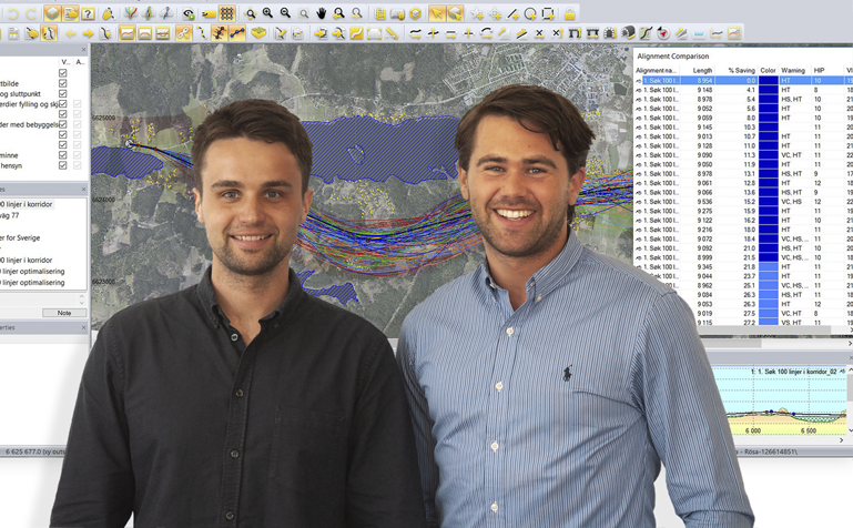
“In this project we calculated and rated one hundred alternative road lines using Quantm,” explains Høie. “The search result that comes up on the screen is a digital map showing all the line alternatives, plus a table listing all road lines in pure text and numbers, based on price and construction cost. All cost elements are rated and justified in tabular form, both in real term costs and in percentage. The cheapest alternative in the Road 77 project was calculated to SEK 89 million in construction costs, and the most expensive one, hundreds of millions. It is difficult to see what constitutes the reasons for these differences just by looking at the lines in the map, but together with the tabular cost listing it becomes very clear.”
Finds the optimal road line
But the search for optimal alignment does not end there: “Once you've found a line that looks very good, you can even optimize this line through another two rounds,” says Høie. “I first made a search for 50 alternatives for this alignment to find the optimal number of breakpoints, both horizontally and vertically, and then a new search of 50 to find optimal placements of the breakpoints. Each of the searches takes just under an hour. The result is the optimal road alignment.”
Detailed design in Novapoint
“Once you have found the optimal road alignment, you can additionally import this into Novapoint Road and Quadri for detailed road model design. The interaction between Quantm and Novapoint is very good. Everything is well facilitated for the user. In Quantm, the road line is simply exported as a LandXML file and imported directly into Novapoint. When the road alignment is imported, it's quick to build a road model with this as a reference line.”
Saves millions in a few hours
“This way you may save millions in construction costs by ensuring the road is optimally planned, designed, and consequently built,” emphasizes Anders Høie.
“The most impressive with Quantm is how quickly the optimization can be done. From the time I got the digital terrain model, to the optimized line was designed in Novapoint, it took only 10 hours, including having evaluated one hundred alignment alternatives and optimized the best alternative. Without using Quantm, this would have taken several months in the traditional way, if at all it is practically feasible. Traditionally one usually assesses just a few alternatives and may therefore miss the optimal line. It´s all about taking all factors into consideration in order to get the best result. Furthermore, every alternative is carefully evaluated, providing a form of quality assurance that is not possible manually.”
“In addition, we got full control over how all the cost elements were distributed. This is a task that would have taken hundreds of hours without using Quantm. It makes enormous time savings to use the tool.”
Great value in the early phase
“It is a big strength of Quantm that you can quickly find the best possible road line at an early stage of the project, and preferably first finding the optimal corridor,” emphasises Hans Forsberg, ÅF's discipline manager for the R77 project. “The tool is also designed to find the best corridor in the landscape. Obviously, much is dependent on the working space you have. The earlier you can start utilizing the tool together with the project owner, the better is the chance to achieve the best possible result.”
“We have had very good usage of Quantm in project meetings with the Swedish Transport Administration, where we have presented and discussed the most optimal line alternatives. It has led to good dialog and better decision-making. As we understand, they think this is an effective way of working.”
Simpler consensus
“For example, we can directly show how the different elements affect the price and costs,” explains Høie. “With the line alternatives interactively available on a big screen, it becomes much easier to get a consensus. With a few clicks, you can evaluate and visualize what happens if parameters are changed. You can immediately see the result of the change, both on the map and in terms of the cost elements in plain numbers.”
“I could even have chosen to simulate optimized lines in a 3D viewer in Quantm, and imported the best line alternatives into Novapoint and evaluate them three-dimensionally in the road model. This provides even more added value to the assessment; and may be worth doing in some contexts. It is up to the project manager and the project owner to choose the one that suits the best. As the alternatives in this way can be displayed and discussed with all stakeholders much easier and safer, it will also be easier for the client to choose the right road alignment solution.”
Optimized road in 10 hours
“During a little long work day, you may in other words evaluate one hundred alignment alternatives, optimize the best alternative, design the road in Novapoint, and calculate the construction costs. Quantm is really effective and quite fascinating to work with,” says Anders Høie.
“We are now also looking at a 4 km long corridor further along the R77 road with Quantm, and we hope we also can use the tool in more projects going forward. The more you use the tool and find your most effective way of using it, the more you can make the most of it. It is undoubtedly a very good analysis tool, which is easy to understand and easy to use,” concludes ÅF´s Hans Forsberg.